Today’s stats: ± 14km hike; start: 11:00, 2153m; brunch: 12:30-14:00, 2356m; finish: 19:35, 3261m
 We woke up after a good night’s sleep, and I for one was glad we had decided to sleep in. An 8hr, 18km hike uphill (100m ascending, 250m descending) is quite some effort for me, apparently. Moreover, the primary effects of the brutal sun of yesterday were rather apparent, on both on me and on Aga.
 yesterday. That was after a 6 hour walk... remember, we're doing this for fun! :)") And I can add that the secondary effects (that is, the burning sensation) was present too. Admittedly, it was all doable, but it wasn’t a stroll in the park. I was very happy that we had a hotel room with bath tub, foot bath, mini bar, restaurant and (the best part) decent beds! I also think it helped us a lot, we were both more or less done for.
And I can add that the secondary effects (that is, the burning sensation) was present too. Admittedly, it was all doable, but it wasn’t a stroll in the park. I was very happy that we had a hotel room with bath tub, foot bath, mini bar, restaurant and (the best part) decent beds! I also think it helped us a lot, we were both more or less done for. So, this morning, we took things relatively slowly. Moreover, we diligently prepared for the sun, me by applying copious amounts of the wrong stuff — foot cream on my face :). We checked out by 12, and skipped breakfast. The idea was to have a brunch at the base station of the cable car (“Teleferique”). It was only about 2km away, and there was a asphalt road running there, so we should be there in half an hour. Right?
Guess again. No seriously, go on, guess :)
I’ll give you some time to ponder it, while you look at today’s goal — which, incidentally, we’re approaching so far from the right, that it’s nowhere near on this photo.

 Bingo. Since we started off easy, and figured we had sufficient time today, we took the nice route and not the asphalt road. Our reasoning was that it would be prettier, nicer to walk, and much less cars to dodge. We were right on all accounts. Hooray! In addition, it was also more sandy – more beachy, if you will. You know, the dense stuff, which saps your energy. You can almost feel the ground siphoning off energy from your legs. Before the start of this day’s hike, I think both of us silently envisioned the first part as the relaxed 30 minutes before waking up. Not quite, apparently. It took a while (about an hour and a half, as a matter of fact), but we finally made it back to asphalt. By then, a solid ground was a blessing.
 We were also right below the base station of the Teleferique. Nice! Not so nice part: it was quite a bit higher up, and we needed to take the long way round to get there. Luckily, this time we were on asphalt, so we made good time and in about 25 minutes, we finally found us at the restaurant. Yup, somewhat behind schedule, but okay: breakfast time! By then it was actually lunch time, which was extra nice, seeing as the restaurant provided a nice, hot lunch buffet. We dipped in, sat down, took off shoes and socks (and earned ourselves some funny looks at that), and took it easy for about an hour and a half. Well, we earned it, no?
 |
 |
") |
 After that break, we treated ourselves to an ice cream and walked back down to the main road (around 14:00). We followed the main road until we hit the start of the track up El Teide. It was “light”, as in “doable by a car”. The road was also wide enough for a car, as you can see from the pictures. Immediately at the start, we were confronted with our current elevation: even though it was 25 degrees and we were hiking in shorts, the shadows still held snow! A short while later, we had elevated enough for the landscape to open up,
 and wide vistas became available. It was truly gorgeous. I have to admit, that I was beginning to worry a bit about our schedule. We started upon this wide track at roughly 16:00, and the information sign at the beginning warned that it was a 4.5 hours hike to the refuge. That would mean we’d be hiking up the mountain in the dark – something I was definitely not looking forward to, even though with this road it’d be okay.
 of the volcano.")
 Of course, to compound my worries, Aga started showing signs of height-induced fatigue. She was having a hard time breathing. That’s at least what she said it felt like – I couldn’t (and can’t) relate to it, as I didn’t have any problems at all. It was weird to see the sporty girl slowing down to the point where I was actually making better progress than her. I took the opportunity to deprive her of her camera, and kept myself behind her by starting to take pictures whenever I threatened to overtake her. It was fun, and it led to quite a number of pictures (you can do the clickety thingy to see ’em). Unfortunately, tiny photos do not do justice to wide landscapes. Aga said she’d look into stitching some together for a few landscape views, so perhaps.
 While hiking up along the road, we were at one point overtaken by a pair of runners. They were wearing running-only gear, with a bottle at the back. Apparently, they were doing some serious training… the road constantly went up. Hard stuff! At any rate, we kept up, and didn’t see them again while the road kept going up. By now, we both had changed into something warmer, as the wind was too cool for comfort, and at this road, we were just too exposed. There was no shelter – I diligently applied sun cream (not foot cream – once was enough ;) at every rest stop. The snow was becoming more annoying. Where first it was an interesting phenomena on the side, at times it now was running over the road to such an extent that the only way onwards was over the snow. As I was wearing sneakers, and as we still had to get to the hard part, I really didn’t want to get my feet wet. Luckily enough, the snow wasn’t melting, and my feet stayed dry.
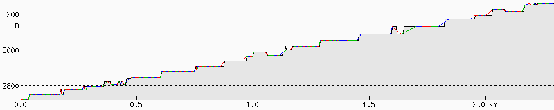
 Then we came upon the steep uphill part. There was a clear break: the car-passable part of the road ended, and a footpath began. As you can see from the height profiles below, the slope of the first part was ± 500m per ± 11km, while the slope of part deux was roughly ± 450m per ± 2.4km(!). Le ouch. Oh, and there was a new information sign. The sign gave no duration, only a severe warning: only do this if you’re in top-notch condition! I felt up to it, but by now Aga was clearly not having an easy time… and it was about six o’clock. Ah well, nothing for it now, we were committed. So, up we went.
 After about half an hour, we encountered the runners again, on the way down. They had actually ran up this steep ascent?! Holy cow, that’s some training! They gave us an estimate of how long we still had to go. Actually, they gave two: 25 minutes and 40 minutes. In the end, both estimates were off by about more or less one hour. It got colder, Aga got grumpier and more quiet, it got darker, and there was little I could do. The road was, incidentally, a lot more adventurous now: far steeper, less wide, and more snow. All in all, a lot more interesting.
In the end, we made it to the refuge. Hooray! I had hoped for a shower, and I expected that there would be almost nobody. Wrong on both accounts! There was only cold water and no showers available, and the place was packed! There was a group of about 10 Italians, with whom we were sharing the room. Moreover, there was a large contingent of “Bombaderos” – firemen from one of the other Canarian Islands. About 30 of them. All in all, the refuge was about full! Luckily we called ahead – something I hadn’t thought necessary, but this time, I was happy we had done so.
 Despite our lateness, we weren’t the last to show up. When we were having dinner, we joined a table where a Polish guy and a Brit, who had come in after us, were sitting. The Brit was shivering. He introduced himself as Warren, and didn’t have a bite to eat. He expected that there’d be something here. Naturally, we couldn’t leave him like that. Aga had prepared a wonderful insta-cream soup, which genuinely filled. On top of that, we had our emergency sandwiches from Hotel Parador, in case we went crazy with hiking (to the top of Teide and down again in one day). Despite Warren’s adamant refusal, we supplied him, and you could see the life flowing in him as the soup warmed him from the inside.
 After dinner, we took a few photos of the incredible views (see also below, click for the big link), including the mighty shadow of El Teide him(her?)self. In the setting sun, this shadow extended all the way to the next island (Las Palmas). Mind you, that’s a few hours by boat from the coast, and we were nowhere near the coast. Later, I tried to take some pics of the fantastically clear night sky. It more or less worked, but I find the pictures disappointing. They look more like digital artifacts than the wondrous clear night sky where stars slowly came to life as the sun set. Yes, it was enough to make me poetic :)
")
Before trying to sleep in a room filled with noisy Italians, I figured to make sure we’d have some water for the next day. So far, we had taken four bottles of water every day. It was too much every day, though never by very much. Problem: there was a warning sign against consuming the water at the refuge. Solution: cook the water, put the pan outside till sufficiently cooled. It still took a while, despite it being dastardly cold outside in the night. But then again: clear sky, 3250m above sea level… I guess there’s a reason it was cold :)
Today’s vital stats
Start: ±11:00, 2153m
Brunch: 12:30-14:00, 2356m
Arrival: 19:35, 3261m
Total distance: ±14km.
Height profile for today in two parts, because the tool couldn’t handle it in one go :s. The easy part (2153m – ±2800m):
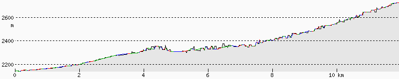 (Can you spot where our brunch was? It’s at the first peak :)
And the not-so-easy part (±2800m – ±3250m) :
And finally, a rough sketch of the trail we hiked (especially off in the beginning, it’s hard to see the route on Google maps there):
[iframe http://maps.google.com/maps/ms?ie=UTF8&hl=en&t=p&msa=0&msid=212454888926572938696.0004a0a59305abdf345df&ll=28.251469,-16.617336&spn=0.056705,0.036478&z=14&output=embed 425 750]View Tenerife Hike day 2 in a larger map
Note: total distance estimate is based on this map, while for the height profiles, I had to redo all this clicking in another map applet :s